


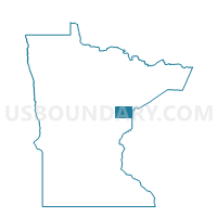
Scanlon Voting District, Carlton County, Minnesota
About
Outline

Summary
| Unique Area Identifier | 601342 |
| Name | Scanlon Voting District |
| County | Carlton County |
| State | Minnesota |
| Area (square miles) | 0.84 |
| Land Area (square miles) | 0.84 |
| Water Area (square miles) | 0.00 |
| % of Land Area | 100.00 |
| % of Water Area | 0.00 |
| Latitude of the Internal Point | 46.70647960 |
| Longtitude of the Internal Point | -92.42990710 |
Maps


Graphs
Select a template below for downloading or customizing gragh for Scanlon Voting District, Carlton County, Minnesota


Neighbors
Neighoring Voting District (by Name) Neighboring Voting District on the Map
- Cloquet W-1, Carlton County, MN
- Cloquet W-2, Carlton County, MN
- Thomson Twp. Voting District, Carlton County, MN
- Twin Lakes Twp. Voting District, Carlton County, MN
Top 10 Neighboring County Subdivision (by Population) Neighboring County Subdivision on the Map
- Cloquet city, Carlton County, MN (12,124)
- Thomson township, Carlton County, MN (5,003)
- Twin Lakes township, Carlton County, MN (2,108)
- Scanlon city, Carlton County, MN (991)
Top 10 Neighboring Place (by Population) Neighboring Place on the Map
Top 10 Neighboring Unified School District (by Population) Neighboring Unified School District on the Map
Top 10 Neighboring State Legislative District Lower Chamber (by Population) Neighboring State Legislative District Lower Chamber on the Map
Top 10 Neighboring State Legislative District Upper Chamber (by Population) Neighboring State Legislative District Upper Chamber on the Map
Top 10 Neighboring 111th Congressional District (by Population) Neighboring 111th Congressional District on the Map
Top 10 Neighboring Census Tract (by Population) Neighboring Census Tract on the Map
- Census Tract 704, Carlton County, MN (7,822)
- Census Tract 701, Carlton County, MN (5,173)
- Census Tract 702, Carlton County, MN (3,924)